Trail Walking La Chapelle-d'Abondance - Le Linleu 2093 m, depuis Sevan-devant - Photo

Le Linleu 2093 m, depuis Sevan-devant

 tracegps
tracegps

User

© OpenStreetMap contributors
Length
Length
5.1 km
Max alt
Max alt
1996 m
Uphill gradient
Uphill gradient
503 m
Km-Effort
Km-Effort  
11.9 km
Min alt
Min alt
1556 m
Downhill gradient
Downhill gradient
507 m
Boucle
Boucle
Yes
Creation date :
2014-12-10 00:00:00.0
Updated on :
2014-12-10 00:00:00.0

(1 Reviews)

Walking
Walking
3h00
Difficulty : Medium

Scan this QR Code to open this trail in the SityTrail application

FREE GPS app for hiking

Logo SityTrail SityTrail

IGN / Geographical institutes

Download SityTrail from the App Store Download SityTrail from Google Play

Logo SityTrail SityTrail World

The world is yours!

Download SityTrail from the App Store Download SityTrail from Google Play Download SityTrail on Huawei AppGallery

About

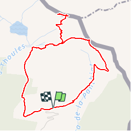
Trail Walking of 5.1 km to be discovered at Auvergne-Rhône-Alpes, Upper Savoy, La Chapelle-d'Abondance. This trail is proposed by tracegps.

Description

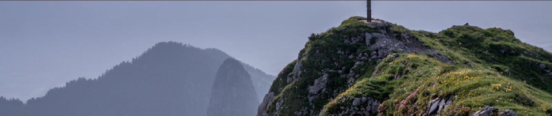
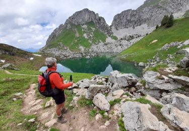
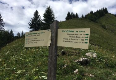
L'ascension du Linleu est une courte randonnée intéressante à retenir pour son point de vue exceptionnel sur les Cornettes de Bise et les sommets du Chablais. Depuis Sevan-devant, lieu-dit de la Chapelle-d'Abondance, l'itinéraire grimpe l'alpage de Braitaz jusqu'au Col d'Outanne. Une traversée jusqu'au Col de Sevan dépose au pied du Linleu. Un bon sentier permet un aller er retour à la croix dressée à proximité du sommet. De retour au Col de Sevan, une sente terreuse descend son versant Ouest jusqu'à la piste pastorale du Lac d'Arvouin pour un retour tranquille au point de départ. Description complète sur sentier-nature.com : Le Linleu 2093 m, depuis Sevan-devant. Avertissement [Exposition 1/3 ; Pénibilité 2/3]. Certains passages de cet itinéraire de montagne sont escarpés et/ou exposés, il est déconseillé aux enfants non accompagnés et aux personnes sujettes au vertige. Pour votre sécurité, nous vous invitons à respecter les règles suivantes : être bien chaussé, ne pas s'engager par mauvais temps, ne pas s'écarter de l'itinéraire ni des sentiers.

Elevation profile

Photos

Positioning

Country:
France
Region :
Auvergne-Rhône-Alpes
Department/Province :
Upper Savoy
Municipality :
La Chapelle-d'Abondance
Location:
Unknown
Start:(UTM)
331779 ; 5130268 (32T) N.

Comments

Please log in to post a review or rate the element


Super trace sympa. La descente est un peu technique car escarpée et glissante. Traversée d'alpage, crêtes, marmottes, forêt au retour,...trace variée. Accessible avec une bonne condition physique et l'habitude de randonner.


Trails nearby

Trail Walking La Chapelle-d'Abondance - Les Cornettes de Bise par le sentier de Saix Rouquin - Photo
Walking
tracegps

Walking

Difficult
(1)
La Chapelle-d'Abondance, Auvergne-Rhône-Alpes, Upper Savoy, France
10 km | 25 km-effort
6h 30min
Yes
Trail Walking La Chapelle-d'Abondance - Cascade boucle 2 - Photo
Walking
Derrendinger

Walking

Difficult
(1)
La Chapelle-d'Abondance, Auvergne-Rhône-Alpes, Upper Savoy, France
10.1 km | 14.9 km-effort
3h 23min
Yes
Trail On foot Vouvry - Miex-Lac Tanay (via Prélagine) - Photo
On foot
PRO

On foot

Easy
Vouvry, Valais/Wallis, Monthey, Switzerland
6.3 km | 9.9 km-effort
2h 15min
No
Trail On foot Vionnaz - Torgon village - Chalet de Blancsex - Photo
On foot
PRO

On foot

Easy
Vionnaz, Valais/Wallis, Monthey, Switzerland
4.4 km | 8.7 km-effort
1h 58min
No
Trail On foot Vionnaz - Torgon village - Dravers - Photo
On foot
PRO

On foot

Easy
Vionnaz, Valais/Wallis, Monthey, Switzerland
4 km | 8.3 km-effort
1h 53min
No
Trail Snowshoes Châtel - Petite  Châtel - Photo
Snowshoes
GUIDE
pascalou73

Snowshoes

Medium
Châtel, Auvergne-Rhône-Alpes, Upper Savoy, France
5.7 km | 10.6 km-effort
2h 0min
Yes
Trail Walking La Chapelle-d'Abondance - lac darbon - Photo
Walking
tof38

Walking

Easy
(1)
La Chapelle-d'Abondance, Auvergne-Rhône-Alpes, Upper Savoy, France
5.9 km | 13.7 km-effort
3h 54min
No
Trail Walking La Chapelle-d'Abondance - CORNETTES DE BISE: LAC DE DARBON - Photo
Walking
djeepee74

Walking

Medium
La Chapelle-d'Abondance, Auvergne-Rhône-Alpes, Upper Savoy, France
7.7 km | 16 km-effort
3h 30min
Yes
Trail Walking La Chapelle-d'Abondance - Cheyenne - Mens - Col d'Ubine - Photo
Walking
boisacq

Walking

Very easy
La Chapelle-d'Abondance, Auvergne-Rhône-Alpes, Upper Savoy, France
6.9 km | 13.2 km-effort
3h 0min
Yes


Close
My subscriptions